Kottappuram Fort, right at the mouth of the River Periyar, is a tribute to the Portuguese military genius. The fort tells the story of the rise and fall of many rulers through four centuries. It is about 4 km on the Kodungallur-Moothakunnam road, in the village of Methala.
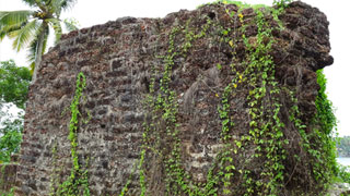
Built in 1523, the Cranganore or Kodungallur Fort later came to be known as the Kottappuram Fort. The fort that had bastions fitted with guns housed military barracks, bungalows and places of worship. In January 1663, the Dutch seized control of this fort. During the Mysore invasion of the 18th century, the then Travancore government bought this fort from the Dutch. But in 1790, Tipu Sultan conquered the fort and destroyed it. In the end, when the British defeated Tipu Sultan, Travancore got the fort back. By then, all the buildings had got demolished. The fort became reduced to just a few walls here and there and a few run-down bastions.
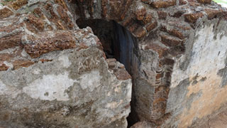
The Cranganore Fort or the Kodungallur Fort has numerous structural remains of historical importance. The nearly two-and-a-half acre area on which the fort used to stand is now seen at three levels. Excavation is in progress at the fort premises. The major objective of the excavation was to find out remnants of the old fort.
The process of excavation started with clearing of the entire fortification area. Certain structural remains were found after the process of surface clearance. Two walls, one at the northern end and other at the centre of the fortification area were identified along with two bastions and an arched cellar. Quadrants were excavated with an intention to trace out submerged structural remains and also to level the entire fortification area. Further excavation in the trenches mainly revealed little flight of steps, a massive laterite wall, mud rammed floor etc. Major Artifacts unearthed included coin, door hinges, clamps, cannon balls made of stone and iron, different types of nails etc. Roof tiles, Bricks having non indigenous character and square shaped floor tiles were also unearthed during the excavation.
The Pattanam excavations were the first ever multi-disciplinary excavations undertaken in Kerala State. The main objective of the excavation was to search for archaeological evidence that would help to locate/identify an early historic urban settlement and the ancient Indo-Roman port of Muziris or Musiri on the Malabar Coast.

The site at Pattanam covers approximately 1.5 sq. km and the core area measures about 600 x 400 m. The north-eastern part of the site was chosen for excavation based on the surface exploration undertaken earlier. The "locus methodology" adopted for this excavation distinguished each layer/feature/pit/structure/ activity area on the basis of color, texture and composition.
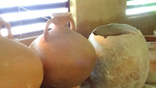
Many important finds were obtained like human bones, storage jars, a gold ornament, glass beads, stone beads, utilitarian objects made of stone, copper and iron, typical pottery, early Chera coins, brick wall, brick platform, ring well, wharf with bollards, and a six meter long wooden canoe parallel to the wharf structure about 2.5 m. below surface level.
The structures indicate a vast 'urban' settlement. The excavations suggest that the site was first occupied by the indigenous "Megalithic" (Iron Age) people, followed by the Roman contact in the Early Historic Period. It appears that the site was continuously occupied at least from the 2nd.century BC to the 10th century AD. The maritime contacts of this region during the Early Historic period seem to have been extensive as evidenced by the large number of Roman amphora shreds, a few terra sigillata shreds, Sassanian, Yemenite and other West Asian potteries. Proliferation of roulette ware probably made in the Bengal-Gangetic region signifies the site's importance in the pan Indian context as well.


